Monitoring Subsidence in Tianjin Area Using the Multi-Baseline D-InSAR Technique

Article Preview

Abstract:

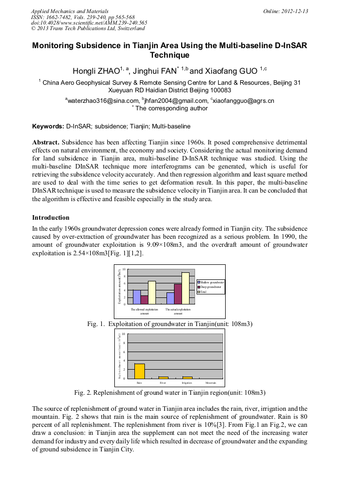
Subsidence has been affecting Tianjin since 1960s. It posed comprehensive detrimental effects on natural environment, the economy and society. Considering the actual monitoring demand for land subsidence in Tianjin area, multi-baseline D-InSAR technique was studied. Using the multi-baseline DInSAR technique more interferograms can be generated, which is useful for retrieving the subsidence velocity accurately. And then regression algorithm and least square method are used to deal with the time series to get deformation result. In this paper, the multi-baseline DInSAR technique is used to measure the subsidence velocity in Tianjin area. It can be concluded that the algorithm is effective and feasible especially in the study area.

You might also be interested in these eBooks

Info:

Periodical:

Pages:

565-568

Citation:

Online since:

December 2012

Export:

Price:

Permissions CCC:

Permissions PLS:

Сopyright:

© 2013 Trans Tech Publications Ltd. All Rights Reserved

Share:

Citation:

[1] F. N. He, G. Wang. The Impact of River Seasonalization on Ground Water and Environment in Haihe Drainage Basin, , Progress In Geography, Vol. 20, No. 3, Science Press, Beijing, pp.286-295, Sep., (2001).

Google Scholar

[2] F. J. Jin. The Study on Urban Water Supply and Consumption of Huabei Plain, Progress In Geography, Vol. 19, No. 1, Science Press, Beijing, pp: 17-24, Mar., (2000).

Google Scholar

[3] X. G. Yang, F. Chen, D. M. Song, F. Gong, W. S. Zhu, Experimental Study on Practical Agricultural Water-saving Measures on Huabei Plain, , Progress In Geography, Vol. 19, No. 2, Science Press, Beijing, pp: 162-166, Jun., (2000).

Google Scholar

[4] Ferretti, C Prati, F Rocca, Nonlinear subsidence rate estimation using permanent scatterers in differential SAR interferometry, , IEEE Trans Geosci Remote Sens, 28(5), pp.2202-2212, (2000).

DOI: 10.1109/36.868878

Google Scholar

[5] P. Berardino, G. Formaro, R Lanari, et al., Anew algorithm for surface deformation monitoring based on small baseline differential SAR interferograms, , IEEE Trans Geosci Remote Sens, 40(11), pp.2375-2383, (2002).

DOI: 10.1109/tgrs.2002.803792

Google Scholar

[6] R. Lanari, O. Mora, M. Manunta, et al. A small-baseline approach for investigating deformations on full-resolution differential SAR interferograms, IEEE Trans Geosic Remote Sens, 42(7), pp.1377-1386, (2004).

DOI: 10.1109/tgrs.2004.828196

Google Scholar

[7] T. Wu, H. Zhang, C. Wang et al. Retrieval of urban slow deformation using the multi-baseline D-InSAR technique, Chinese Science Bulletin. vol. 53 no. 23, Science Press, Beijing, pp.3705-3714, December (2008).

DOI: 10.1007/s11434-008-0331-4

Google Scholar