Research on Environmental Features Description and Extraction Based on Cylindrical Log-Polar Coordinate

Article Preview

Abstract:

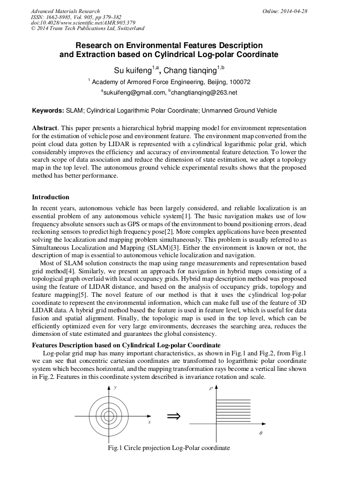
This paper presents a hierarchical hybrid mapping model for environment representation for the estimation of vehicle pose and environment feature. The environment map converted from the point cloud data gotten by LIDAR is represented with a cylindrical logarithmic polar grid, which considerably improves the efficiency and accuracy of environmental feature detection. To lower the search scope of data association and reduce the dimension of state estimation, we adopt a topology map in the top level. The autonomous ground vehicle experimental results shows that the proposed method has better performance.

You might also be interested in these eBooks

Info:

Periodical:

Pages:

379-382

Citation:

Online since:

April 2014

Export:

Price:

Permissions CCC:

Permissions PLS:

Сopyright:

© 2014 Trans Tech Publications Ltd. All Rights Reserved

Share:

Citation:

* - Corresponding Author

[1] Vincent R, Ecker M. Light detection and ranging (LiDAR) technology evaluation. Technical report(2010).

Google Scholar

[2] Li, Y., & Olson, E. B. Extracting general-purpose features from lidar data. 2010 IEEE International Conference on Robotics and Automation (ICRA) , 2010, pp.1388-1393.

DOI: 10.1109/robot.2010.5509690

Google Scholar

[3] Lu, Zheyuan, Zhencheng Hu, and Keiichi Uchimura. SLAM estimation in dynamic outdoor environments: A review. Intelligent Robotics and Applications. Springer Berlin Heidelberg, 2009 pp.255-267.

DOI: 10.1007/978-3-642-10817-4_25

Google Scholar

[4] Roh, Hyun Chul, et al. Fast SLAM using polar scan matching and particle weight based occupancy grid map for mobile robot. 8th International Conference on Ubiquitous Robots and Ambient Intelligence (2011).

DOI: 10.1109/urai.2011.6146004

Google Scholar

[5] Moras, Julien, Véronique Cherfaoui, and Philippe Bonnifait. A lidar perception scheme for intelligent vehicle navigation. 11th International Conference on Control Automation Robotics & Vision (2010).

DOI: 10.1109/icarcv.2010.5707962

Google Scholar

[6] Narayana, K., Goulette, F., & Steux, B. Planar landmark detection using a specific arrangement of LIDAR scanners. In Position Location and Navigation Symposium (2010), pp.1057-1069.

DOI: 10.1109/plans.2010.5507336

Google Scholar

[7] Schaffalitzky F, Zisserman A. Planar grouping for automatic detection of vanishing lines and points. Image and Vision Computing, 18(9) 2000, p.647–658.

DOI: 10.1016/s0262-8856(99)00069-4

Google Scholar