Removing Cloud of Grey Remote Sensing Image Based on Network Communication

Article Preview

Abstract:

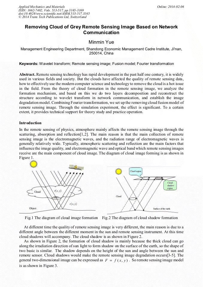
Remote sensing technology has rapid development in the past half one century, it is widely used in various fields and society. But the clouds have affected the quality of remote sensing data, how to effectively use the modern computer science and technology to remove the cloud is a hot issue in the field. From the theory of cloud formation in the remote sensing image, we analyze the formation mechanism, and based on this we do two layers decomposition and reconstruct the structure according to wavelet transform in network communication, and establish the image degradation model. Combining Fourier transformation, we set up the removing cloud fusion model of remote sensing image. Through the simulation experiment, the effect is significant. To a certain extent, it provides technical support for theory study and practice operation.

You might also be interested in these eBooks

Info:

Periodical:

Pages:

3165-3169

Citation:

Online since:

February 2014

Authors:

Export:

Price:

Permissions CCC:

Permissions PLS:

Сopyright:

© 2014 Trans Tech Publications Ltd. All Rights Reserved

Share:

Citation:

* - Corresponding Author

[1] Xingfang Jiang, Xingfang Xiang. Removing cloud of grey remote sensing image and quality analysis [J]. Laser technology, 2010, (3): 112-113.

Google Scholar

[2] Yongjie Huang, Shuguo Wang, etc. Removing cloud algorithm of remote sensing image [J]. Chinese Journal of scientific instrument, 2012, 24 (4): 89-90.

Google Scholar

[3] Jie Kong. Removing cloud of remote sensing image clouds with support vector machine [D]. Anhui University, 2010: 1-12.

Google Scholar

[4] Hongli Li, Hongli Shen, Bo Du, Ke Wu. A thin cloud removing of remote sensing image fidelity homomorphic filtering method [J]. Remote sensing information, 2011 (2): 132-133.

Google Scholar

[5] Xiaodong Zhang. Research and implementation a thin cloud removing of remote sensing image [D]. Research at the Civil Aviation College of China, 2010: 2-10.

Google Scholar

[6] K.R. Castleman. Digital image processing [M]. Beijing: Publishing House of electronics industry, 2012: 324-334.

Google Scholar

[7] Tongying Guo, Hongjian You. Removing cloud of remote sensing images based on wavelet fusion of multidate [J]. Bulletin of Surveying and mapping, 2011 (3): 40-42.

Google Scholar

[8] Mingyuan Zhang, Hongli Wang, Hongli Chen. Research on removing cloud of multi-source image based on wavelet analysis [J]. Sensor and micro system of fusion, 2010, 26 (11): 19-21.

Google Scholar

[9] Xiangqian Guo. Research on thin cloud removing of CBERS_02 image based on wavelet transform [J]. Science of surveying and mapping, 2011, 33 (1): 57-59.

Google Scholar

[10] Jianguo Ling, Jianguo Liu, Xin Xu etc. Variable resolution color image segmentation based on entropy [J]. Journal of Shanghai Jiao Tong University, 2012, 39 (12): 1975-(1978).

Google Scholar

[11] Shuang Cao, Hao Li, Wen Ma. Thin cloud removing method of sensing image based on mathematical morphology [J]. Geography and geo information science, 2010 (3): 78-79.

Google Scholar