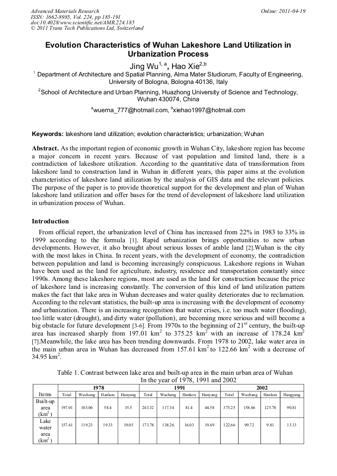
[1]
J. Cheng, J. Turkstra and Y. Xiao: The Changing Urban Fabric of Chinese Cities, Wuhan 1955–2000, Urban Geo-informatics (Wuhan University Press, China 2001).
Google Scholar
[2]
T. Firman, Land Conversion and Urban Development in the Northern Region of West Java, Indonesia, Urban Study, 34 (7) (1997), p.1027–1046.
DOI: 10.1080/0042098975718
Google Scholar
[3]
H. Wang, J. Zhang and H. Wang, On the Urban Water Crisis and its Countermeasures, Journal of Hebei Institute of Architectural Engineering, 24 (1) (2006), p.17–22.
Google Scholar
[4]
WSB In: Wuhan Statistical Bureau (WSB), Editor, Wuhan Statistical Yearbook (China Statistical Press, China 2006).
Google Scholar
[5]
W. Xiang, GIS-based Riparian Buffer Analysis: Injecting Geographic Information into Landscape Planning, Landscape Urban Plan, 34 (1) (1996), p.1–10.
DOI: 10.1016/0169-2046(95)00206-5
Google Scholar
[6]
N. Dua, H. Ottensb and R. Sliuzas, Spatial Impact of Urban Expansion on Surface Water Bodies—A Case Study of Wuhan, China, Landscape and Urban Planning, Volume 94, Issues 3-4, 15 March (2010), pp.175-185.
DOI: 10.1016/j.landurbplan.2009.10.002
Google Scholar
[7]
Information of Wuhan Statistical Bureau, Report of 60th Anniversary of the Founding of the People's Republic of China, (2002).
Google Scholar
[8]
I. Masser, Managing Our Urban Future: The Role of Remote Sensing and Geographic Information Systems, Habitat Int., 25 (2001), p.503–512.
DOI: 10.1016/s0197-3975(01)00021-2
Google Scholar
[9]
J. Cheng and I. Masser, Urban Growth Pattern Modeling: A Case Study of Wuhan City, PR China, Landscape and Urban Planning, Volume 62, Issue 4, 25 February (2003), pp.199-217.
DOI: 10.1016/s0169-2046(02)00150-0
Google Scholar
[10]
H. Xinyuan, M. Jinsong and T. Qin: The Introduction of Geographic Information System (Higher Education Press, China 2001).
Google Scholar
[11]
The Twenty-nine Meeting of Standing Committee of 10th National People's Congress Adopted Regulations of Urban Lake Protection of Wuhan (2002).
Google Scholar
[12]
J.C.M. Laurence and W.H. Edward: Urban Development in Modern China (Westview Press, Boulder 1981).
Google Scholar
[13]
The Sixteenth Meeting of the Standing Committee of the Sixth National People's Congress Adopted the Law of Land Administration (1986).
Google Scholar
[14]
It was approved by the Fourth Meeting of the Ministry of Land and Resources on April 3, 2002, issued on the order from the Ministry of Land and Resources No. 11 on May 9, 2002 and put into force on July 1, (2002).
Google Scholar
[15]
Information on http: /www. digitalwuhan. gov. cn/tdjy/index. asp.
Google Scholar
[16]
Information on http: /www. digitalwuhan. gov. cn/pt-2-310-320-0-2. html.
Google Scholar