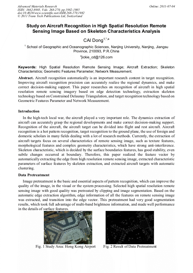
[1]
K. Li, R. WANG, C. WANG. A Method of Tree Classifier for the Recognition of Airplane Types[J]. Computer Engineering & Science, 2006, 11: 136-139.
Google Scholar
[2]
K. Xu. Recognition of Remote Sensing Target Based on Wavelet Transform and Support Vector Machine[J]. Computer & Digital Engineering, 2007(7): 123-125.
Google Scholar
[3]
Y. Hu, S. Wang, B. Hou, L. Jiao. REMOTE SENSING TARGET RECOGNITION BASED ON SWBCT AND PROJECTION FEATURE[J]. Journal of Infrared and Millimeter Waves, 2007(6): 51-455.
Google Scholar
[4]
J.H. Xu. Mathematics Method of Modern Geography[M]. Higher Education Press, (2002).
Google Scholar
[5]
P. Hu, H. Wang, C. Shao. Polygon Medial Axis Problem and the Algorithm[J]. Editorial Board of Geomatics and Information Science of Wuhan University, 2005(10): 853-857.
Google Scholar
[6]
F. Chin, J. Snoeyink, C.A. Wang. Finding the Medial Axis of a Simple Polygon in Linear Time. London: Springer-Verlag, (1995).
Google Scholar
[7]
Z.L. Li, Q. Zhu. Digital Elevation Mode[M]. Wuhan University Press, (2001).
Google Scholar
[8]
T.H. Ai, R.Z. Guo. Extracting Center-lines and Building Street Network Based on Constrained Delaunay Triangulation[J]. ACTA GEODAETICA ET CARTOGRAPHIC SINICA, 2000(4): 348-354.
Google Scholar
[9]
L.M. Huang, Y.P. Zhang. The Automatic Create Method of Framework Lines of Area by Trianglated Network[J]. Journal of The Pla Institute of Surveying and Mapping, 2002(4): 262-264.
Google Scholar
[10]
P.H. Swain, H. Hauska. The decision tree classifier design and potential [J]. Proceedings of IEEE, 1977, GE_15(3): 142~147.
DOI: 10.1109/tge.1977.6498972
Google Scholar
[11]
J. Yang, Z.M. Zhao, J. Yang. A Shadow Removal Method for High Resolution Remote Sensing Image[J]. Geomatics and Information Science of Wuhan University, 2008(1): 17-20.
Google Scholar
[12]
Y. Li, T. Sasagawa, P. Gong. A System of the Shadow Detection and Shadow Removal for High Resolution City Aerial Photo[C]. ISPRS, Commission Ⅲ, Istanbul, (2004).
Google Scholar
[13]
M.N. Do, M. Vetterli. Contour lets: adirectional multi-resolution image representation [C]. International Conference on Image Processing, 2002 (1), 357-360.
Google Scholar
[14]
B. Bhanu, P. Jing. Adaptive integrated image segmentation and object recognition [J]. IEEE Transactions on Systems, Man and ybernetics_Part C, 2000, 30(4): 427~441.
DOI: 10.1109/5326.897070
Google Scholar
[15]
N. Halem. Contextual, Image Understanding of Airport Piotographs, SPIE, 1981: 1521-1532.
Google Scholar