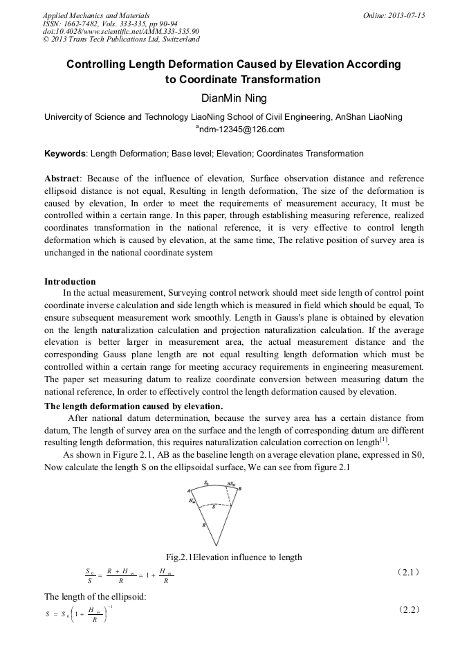
Controlling Length Deformation Caused by Elevation According to Coordinate Transformation

Article Preview

Abstract:

Because of the influence of elevation, Surface observation distance and reference ellipsoid distance is not equal, Resulting in length deformation, The size of the deformation is caused by elevation, In order to meet the requirements of measurement accuracy, It must be controlled within a certain range. In this paper, through establishing measuring reference, realized coordinates transformation in the national reference, it is very effective to control length deformation which is caused by elevation, at the same time, The relative position of survey area is unchanged in the national coordinate system

You might also be interested in these eBooks

Info:

Periodical:

Pages:

90-94

Citation:

Online since:

July 2013

Authors:

Export:

Price:

Permissions CCC:

Permissions PLS:

Сopyright:

© 2013 Trans Tech Publications Ltd. All Rights Reserved

Share:

Citation:

[1] GuoShengLu. Surveying[M]. Beijing: Surveying and Mapping Press.

Google Scholar

[2] GB50026-2007, engineering survey Code[S]. Beijing: China Planning Press, 2008, 164.

Google Scholar

[3] Junshiding. Research on independent ellipsoid Transformation and Coordinates Conversion[J]. Surveying and Mapping Bulletin, 2008(8). Beijing:Surveying and mapping press, 17.

Google Scholar

[4] Minshiyi, Jianli, WenQingzhang. The Character of the Independent Coordinate System and Determination of the Regional Ellipsoidal Surface[J]. Surveying and mapping Journal, 2001(9). Beijing: Surveying and Mapping Press.

Google Scholar

[5] Minshiyi, Yongjunzhou, WenQingzhang. The Determination of The Regional Ellipsoid Surface by the Method of Readjusting its Orientation and Positioning[J]. Surveying and Mapping Press, 2002. 33(2).

Google Scholar

[6] -7] Haifengyin. The computer-aided deduction of Gauss projection formula[J]. Surveying and Mapping Science, Beijing: Surveying and Mapping Press, Volume thirty-third (2).

Google Scholar

[8] Control measurement adjustment calculation examples[M]. Nanning. The Guangxi Zhuang Autonomous Region geological survey team production, 1973, 159.

Google Scholar