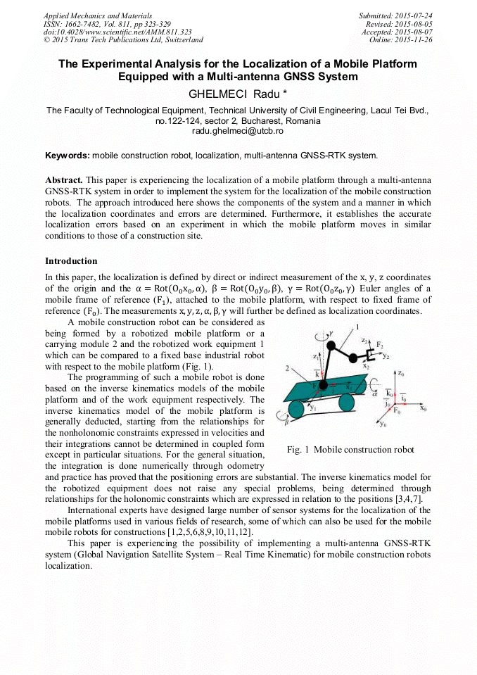
[1]
Beliveau Y., Fithian J., Deisenroth M., Autonomous vehicle navigation with real-time 3D laser based positioning for Construction. In: Autonomous in Construction 5 , pp.261-272, (1996).
DOI: 10.1016/s0926-5805(96)00140-9
Google Scholar
[2]
Borenstein J., Everett H.R., Feng L., Wehe D., Mobile Robot Positioning – Sensors and Techniques. In: Jurnal of Robotic Systems, Special Issue on Mobile Robots, vol. 14, no. 4, pp.231-249.
DOI: 10.1002/(sici)1097-4563(199704)14:4<231::aid-rob2>3.0.co;2-r
Google Scholar
[3]
Dima M., Frâncu C., Ghelmeci R., Determining the Forward Kinematics Model of a Bucket Excavator's Digging Equipment. In: The VIII International Conference Heavy Machinery – HM2014, 2014, Zlatibor, Serbia, pp. A151 – 155.
DOI: 10.4028/www.scientific.net/amm.762.3
Google Scholar
[4]
Dima M., Frâncu C., Ghelmeci R., Determining the Inverse Kinematics Model of a Bucket Excavator's Digging Equipment. In: The VIII International Conference Heavy Machinery – HM2014, 2014, Zlatibor, Serbia, pp. A13 – 16.
DOI: 10.4028/www.scientific.net/amm.762.11
Google Scholar
[5]
Pop C.M., Morgan G.L., Neagu M., Localization and Path Planning for an Autonomous Mobile Robot Equipped with Sonar Sensor. In: Applied Mechanics and Materials, vol. 772, pp.494-499.
DOI: 10.4028/www.scientific.net/amm.772.494
Google Scholar
[6]
Fumihiro Inove, Takeshi Sasahi, Xiangqi Huang, Hideki Hashimoto, A Study on Position Measurement System Using Laser Range Finder and its Application for Construction Work. In: Journal of Robotics and Mechatronics, vol. 24, no. 1, (2012).
DOI: 10.1299/jsmeicam.2010.5.361
Google Scholar
[7]
Ghelmeci R., Dima M., The Localization of the Robotic Mobile Platforms for Constructions with Laser Tracker and Smarttrack Sensor. In: The VIII International Conference Heavy Machinery – HM2014, 2014, Zlatibor, Serbia, pp. D11-15.
Google Scholar
[8]
Goyonneau R., Lagrange S., Hardonin L., Lucidarme P., Guaranteed interval analysis localization for mobile robots. In: Advanced Robotics, vol. 28, no. 16, pp.1067-1077, (2014).
DOI: 10.1080/01691864.2014.908742
Google Scholar
[9]
Joerger M., Pervan B., Range – Domain Integration of GPS and Laser-scanner Measurements for Outdoor Navigation. In: Proceedings of the 19th International Technical Meeting of the Satellite Division of The Institute of Navigation – ION GNSS 2006; 2006, Fort Worth, TX, pp.1115-1123.
DOI: 10.33012/2021.17962
Google Scholar
[10]
Kiichiro Ishikawa, Yoshiharu Amano, Takumi Hashizume, Path Planning for Mobile Mapping System Considering the Geometry of the GPS Satellite. In: Journal of Robotics and Mechatronics, vol. 25, no. 3, (2013).
DOI: 10.20965/jrm.2013.p0545
Google Scholar
[11]
Shigang Li., Localization along routes, based upon iconic and Global Positioning system information in large-scale outdoor environments. In Advanced Robotics, vol. 15, no. 7, pp.749-762, (2001).
DOI: 10.1163/15685530152744608
Google Scholar
[12]
Sukkarieh S., Nebot E.M., Durrant-Whyte H.F., A high integrity IMU/GPS navigation loop for autonomous land vehicle applications. In: Robotics and Automation, IEEE Transactions, vol 15, Issue 3, (1999).
DOI: 10.1109/70.768189
Google Scholar