[1]
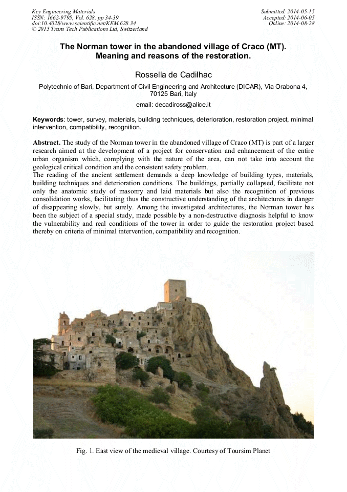
While the upper part of the village is made up of conglomerates, with sandy inserts, erodible and very permeable, the underlying layers are composed mainly by relatively permeable sandy clay, sometimes outcrops, which form the bed of groundwater aquifer. The swelling and the plasticization of the clay causes the sliding downstream of the conglomerates and decaying debris triggering landslide movements. At Craco are observed different types of landslide collapses due to fracturing of the rock conglomerate in NE, soil roto-translational slipping, earth flows and lateral expansions on the southern side.
Google Scholar
[2]
As a result of the first significant landslides, registered in the southern part of the village between 1870 and 1886, in 1888 was made a first arched wall, supporting SS103, 3. 5 m wide. Although it was founded on poles, 18m deep, with drainage outfalls and drain tunnels, the wall suffered, within a short time, an initial 20 cm downstream deflection. More landslides in the same area are documented in 1931, on this occasion the retaining wall was strengthened. In 1952, after the reactivation of the so called del convento" landslide, was made a second wall as a continuation of the previous one, 20 m high, with the aim to secure the above SS103. Fitted with drainage, but without drain tunnels, instead of improving the situation, the wall undermined the stability of the soil, further compromised by the realization, immediately to the south, of a football field on backfill, thereby overloading the SW side. An exceptional rainfall event, occurred in 1959, triggered the reactivation of "old town centre" landslide, which destroyed the football field, caused an extensive movement of the wall and damaged several buildings of the old town centre, resulting in an accumulation of soil at the foot of the sliding for a height of 20m. Following further reactivation of the landslide, on the same side, between 1963 and 1965 geological analysis is undertaken by Walter Brugner. The researcher found an enlargement of landslide fronts and detects a drop of 2 m, as well as 1 m horizontal translation of the wall, further deformed by 50 cm, with a relative lowering of the roadway and damage to the buildings of the old town centre. Brugner attributes the phenomenon to natural causes (progressive wetting of the clay soil with a slip of the conglomerate on the clay bed of the groundwater aquifer) and to anthropic ones (excavation of wells, loss in the water supply and sanitation). When, in 1969, other landslides are recorded the nineteenth century wall was demolished, now without of any function, replaced it with a new retaining wall 60m length, resting on 4m width plates, placed at two different heights and founded on poles over 30 m deep. But within two years, the progress of landslides, culminated in 1971 with the total collapse of the central region of the village near the church. The following flooding that occurred in 1979 and the earthquake that struck Irpinia in 1980, further worsed the situation up to 1991 with the inhabitants evacuation order. Cfr. Brugner W., Sulle condizioni di stabilità dell'abitato di Craco (Provincia di Matera). Relazione Tecnica, 1964, in http: /www. cracoricerche. net/home/node/44; A. Balboni, Trasferimento dell'abitato di Craco, Relazione tecnica, 1964; E. Beneo, Sulla stabilità dell'abitato di Craco. Relazione tecnica, 1967; A. Moretti, Sulle condizioni di stabilità di Craco (MT). Relazione tecnica, 1968; A, Cucari, Sulle condizioni di stabilità dell'abitato di Craco, in conseguenza dell'evento sismico del 23. 11. 1980 verificatosi in Basilicata. Relazione geologica, 1980; AA. VV., Linee guida per la salvaguardia dei beni culturali dai rischi naturali. Analisi per la valutazione del rischio da frana nell, area di Craco (Matera), in http: /www. afs. enea. it/protprev/www/cases/craco/craco. htm.
Google Scholar
[3]
http: /www. cracoricerche. net/home/node/2.
Google Scholar
[4]
The restoration, set up by the municipality, must be organized into three phases: 1. recovery and development of the areas around the old city centre, 2. implementation of a monitoring system that provides data on the landslide evolution 3. take forward actions for building restoration and safety measures, such as: - securing of the fruition paths in the old city centre; - recovery and restoration of buildings for the sole scenic purpose; - recovery and restoration of buildings for a re-use purpose such as production and cultural activities (the Mother Church, Norman Tower, palace Carbone, palazzo Grossi, palazzo Simonetti, palazzo Rigirone-Cammarota); - hydrogeological and landscaping works of the surrounding slopes with experimental and demonstrative interventions (forestation with vegetative variety typical of the area); - rainwater drainage works; - small retaining works.
Google Scholar
[5]
The research takes its inspiration from the theme of a workshop degree, from Polytechnic of Bari, activated during the course of Bachelor of Architecture in the academic year 2013/14 years, led by the writer and dedicated to the theme of the abandoned minor old town centers, with particular attention to Craco that has been selected as a case study. We take this opportunity to thank the leaders of the town of Craco and the team CracoRicerche srl for the availability and cooperation offered to the teachers' and students during the research.
Google Scholar
[6]
B. Capasso, Sul catalogo dei feudi e dei feudatari delle prov. Napoletane, Napoli 1870; T. Pedio, Feudi e feudatari di Basilicata, Matera1967; D. D'Angella, Note storiche sul monte di Craco, Pisticci 1986, p.20.
DOI: 10.1515/9783110910353.583
Google Scholar
[7]
A. Russo, La fabbrica dell'ex convento di S. Pietro a Craco: dal rilievo al restauro, degree thesis discussed during the academic year 2010/2011 at Facoltà di Architettura G. D'Annunzio, di Chieti, supervisor prof. Lucia Serafini, p.2.
Google Scholar
[8]
Catalogus baronum neapolitano in regno versantium qui sub auspiciis Gulielmi Cognomento Boni ad Terram Sanctam sibi vindicandam susceperunt, reproduction by Giovanni de Francesco from copy published in Naples in the 18th century. and owned by the Public Library of Verbania, containing the transcription, based on the one of Charles Borrelli of 1653, of the manuscript Reg Ang. 242, ff. 13r-63r, sl, 1996 (Biblioteca Nazionale Braidense).
Google Scholar
[9]
Without reliable documents, a comparative study (now under study) with similar towers from the typological, constructive and decorative point of view (it might be thought to the fortifications in Grottole, Satriano, Brindisi di Montagna, Monteserico) could provide useful information to purpose of dating.
Google Scholar
[10]
Archivio dell'Acquedotto Pugliese, Bari. Lavori per la costruzione del serbatoio di Craco e delle relative condotte di arrivo e di partenza. Verbale di consegna, 10 agosto 1949. The works, carried out by the Salvatore D'Elia, are directed by the engineer Luigi Lepore and tested by the engineer Vincenzo Solimena.
DOI: 10.2307/j.ctvvb7n40.5
Google Scholar
[11]
The cracks found on the inner face, at the last level, reveal other than a poor toothing of the stone elements with the core wall, also a loss of connection with the masonry bond of the destroyed vault.
Google Scholar